


The government wants to build 4,150 new homes in Jersey by the end of 2025.
It's estimated that around 10% of them will be built on green zone land.
The draft bridging Island Plan has been published today.
The government says the new homes will be a range of types, sizes, and tenure to meet the island's different housing needs.
Of those, 1,500 will be so-called 'affordable homes' for rent and purchase - with the ambition to improve the standard of these properties.
Most of these will be in town, but a strategic plan has been published to try and make it better to live in town by increasing access to green space and community facilities.
It's proposed that a communities fund be established to pay for these improvements. Homes for workers in tourism and agriculture would be supported within the built-up area.
A minimum of 25 key worker units per year would be built and controlled through the government.
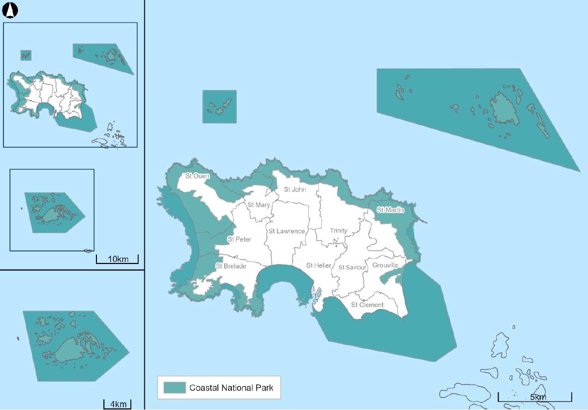
If approved, the Coastal National Park would be extended to increase the protection of sites around the coast and waters, with new historic environment policies in place to strengthen the protection of listed buildings.
"Development within the Coastal National Park should be compatible with the purposes of the park, in order to protect its special qualities. It will need to accord with other policies throughout the plan in terms of the forms of development that may be acceptable within the park, and applicants will need to, in particular, justify the need for development to be located here. It is essential that development in the Coastal National Park protects or improves the landscape and seascape character of the park and ensures that these special qualities can continue to be enjoyed."
A 12-week consultation has opened today for islanders to have a say on the plan.
Representations will be published and considered by the independent planning inspector before the plan is debated by the States next year.
Online briefings will be held next month and in-person discussions will take place in each parish.
"This draft Island Plan is a giant step forward. It updates all our development policies and sets an ambitious vision to enhance Jersey as a special place, protect its environment and unique island identity; and provide the homes, employment and infrastructure that sustain family and community life.
"I want to encourage every Islander to get involved in the 12-week public consultation. Everyone should see this as an opportunity to have their say about the future of the Island and its development, not only in the coming years, but also how we might best respond to the long-term challenges that the Plan identifies.
"Participating in the consultation means your views will be considered by States Members and by the independent planning inspector later this year before the plan is debated in spring 2022.
"The bridging Island Plan is the start of a great future for Jersey, and I want everyone to be involved." -Deputy John Young, Environment Minister.
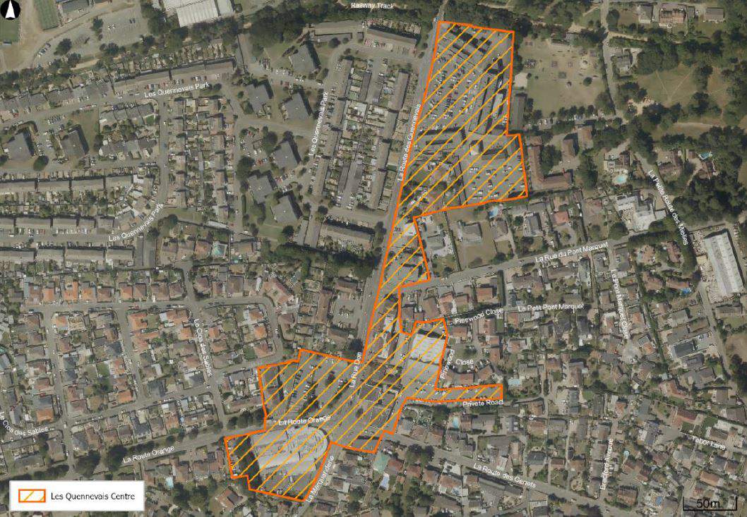
Les Quennevais
The government says Les Quennevais is well-placed to support further development in the built-up area.
"The plan defines a Les Quennevais Centre 'that embraces the precinct and Red Houses crossroads, where there exists a focus of employment land uses in the area, mostly centred around food and other convenience retailing, but with a range of other complementary ‘town centre’ services including pharmacies and other healthcare services, cafés, beauticians, barbers, and other personal services."

It's proposed that new office accommodation of up to 200sqm be built at Les Quennevais to 'encourage investment and further develop employment opportunities in the west of the island'.
Parish centres, historic harbour villages, suburban centres, and areas along the south and east coast - including St Brelade's Bay, Five Oaks, Grands Vaux and First Tower
The government says there are opportunities for development in some of these places, but it must have regard to the character of the area and its ability to accommodate 'more dense forms of development'.
The plan sets out a proposal to create an improvement plan for St Brelade's Bay 'to enhance its character for the benefits of islanders and visitors alike'.
"Any development in local centres needs to be proportionate to the needs of the community, the scale of the built-up area, and appropriate to its context in scale, character and use."
Coastal National Park
It's proposed that the park boundary be extended to cover nearly 30% of the island's landmass, excluding the offshore reefs or the shallow sea areas embraced by the park.
"The Island Plan seeks to ensure that development which takes place within the Coastal National Park protects or improves its landscape or seascape character, and which is also compatible with the purposes of the park, and which does not undermine its special qualities. It is important to acknowledge and recognise that the Island Plan only serves to influence and shape development activity in the national park and can only affect decisions for activities that involve the development of land and buildings."
Building around the coast and in the countryside
The government says there will be a general presumption against building new homes around the coast and countryside 'to promote the most sustainable pattern of development in the island and protect the island's green infrastructure.'
"Agricultural land will be protected from loss and its alternative use will only be supported where it can be justified relative to the nature of the proposed use and the value of the land to agriculture, such that alternative uses will only be appropriate on lower-quality agricultural land. Support will be given to proposals that comprise the reuse or redevelopment of already developed land and/or buildings in the countryside, where it is appropriate and justified, having regard to tests of redundancy.
"The reuse or redevelopment of modern agricultural buildings for non-employment uses will not be supported. Redundant and derelict glasshouses are considered to be temporary structures associated with the agricultural use of the land that should be removed, and the land restored, when they are no longer required.
"The development of derelict glasshouses may only be supported in exceptional circumstances where the extent of development is limited to that which is required to achieve their removal and to deliver an overall enhancement to the countryside."
The plan states that development opportunities will be limited in the Coastal National Park, development in the green zone should protect or improve the landscape character, and development plans in the marine environment will not be supported except where it's proven to be essential.
"This Island Plan resets the boundary for the Coastal National Park and now embraces parts of the marine environment below the high-water mark including the unique intertidal zones and offshore reefs, together with their surrounding shallow waters, where development opportunity will be limited. Development proposals will need to protect or improve the essential and sensitive landscape and seascape character and rich biodiversity of these places."
Tall buildings
A framework could be created against which plans for tall buildings can be assessed.
The plan defines tall buildings where it two or more storeys above the height of the prevailing contextual height and to buildings that are 18 metres or more above ground level.
Proposals for development that exceed the St Helier Urban Character Appraisal's assessment of the capacity of town to successfully accommodate tall buildings will have to give evidence to show there are overriding public benefits to justify the adverse impact of building at such height.
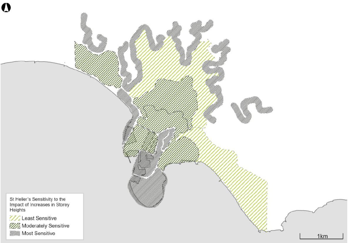
Developments of high-rise buildings over eight storeys in St Helier will not be supported.
"In order to protect the visual character and enjoyment of the island’s urban, rural, coastal and marine environments further development will be strongly resisted where it will be obtrusive and prominent on the skyline and opportunity will be sought to repair it, where possible.
"The scale, height, colour or finish of existing buildings and structures which detract from an important skyline, vista or view will not be accepted as a precedent for their redevelopment where there is an opportunity to repair the skyline, vista or view with more sensitively scaled and designed development, and landscape reparation."
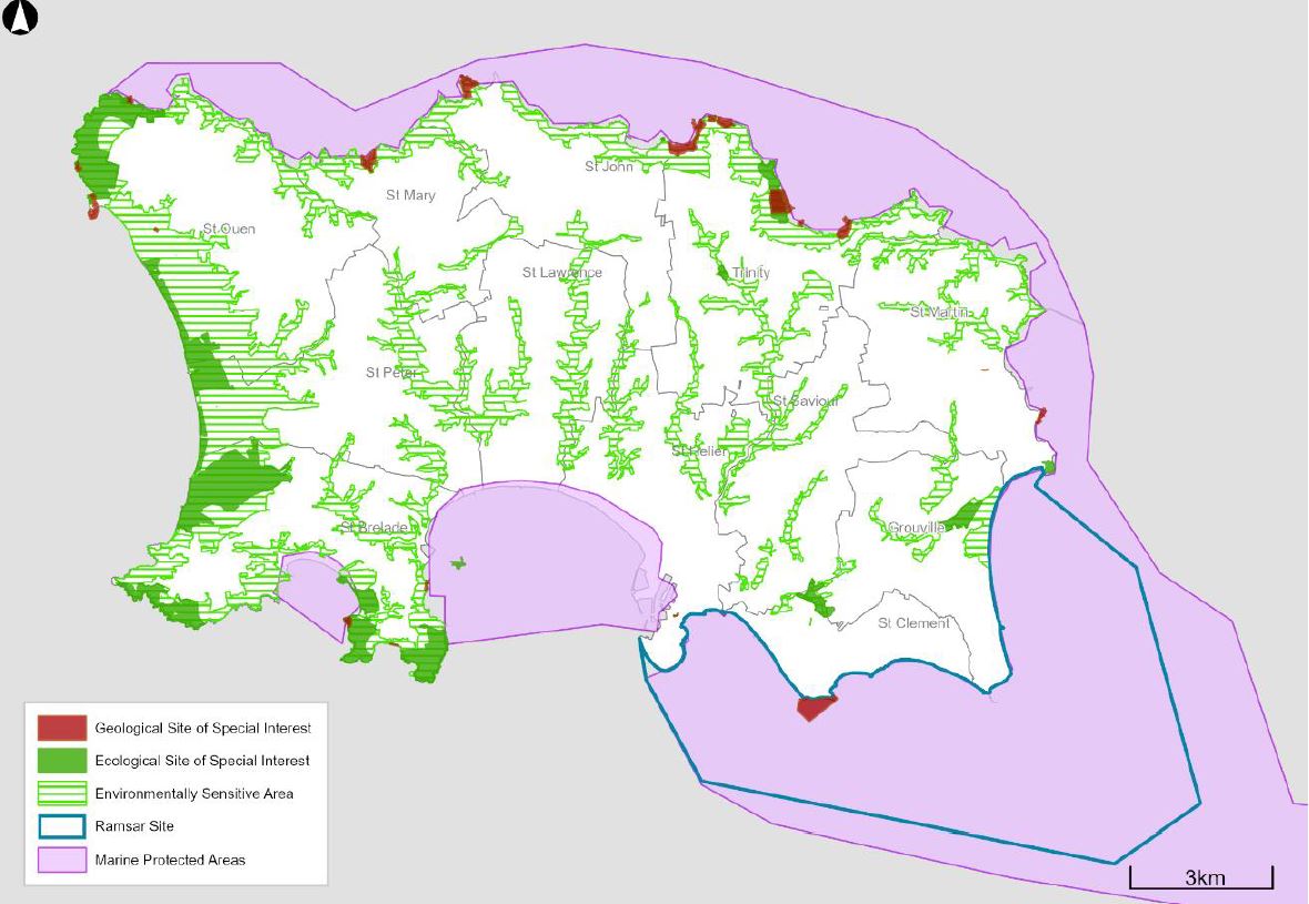
Protecting biodiversity and geodiversity
The government says the highest level of protection will be given to sites of special interest, marine protected areas, and Ramsar sites - with applicants needing to prove that plans will not cause harm to biodiversity of geodiversity value.
"Where development proposals may lead to an impact on biodiversity and geodiversity they must be accompanied by adequate information which demonstrates how biodiversity and geodiversity will be protected, and adverse impact avoided, minimised, mitigated or compensated for."
'Biodiversity net gain' is being proposed as part of this plan to leave the natural environment 'in a measurably better state than beforehand'.
"Further work is needed in Jersey to define the biodiversity net gain and urban greening concepts and to consider how they would operate, including their inter-relationship with existing designations. This work will inform the next iteration of the Island Plan."
Green networks
The plan sets out the aim to improve connection between existing protected sites to increase the overall biodiversity of the island.
A green network allows animals, birds, plants, seeds, nutrients and water the opportunity to spread and move across the island, providing the island’s biodiversity with greater resilience in the face of a changing climate.
"Work has been undertaken to identify priority corridors, which should be enhanced to create a better-connected network of habitats. The areas of the island with the greatest potential to create wildlife corridors lie in the west and southwest of the island and among the wooded valleys and opportunity, through development, should be taken to enhance these, as well as to develop green networks throughout the island."
Plans that impact on trees or hedgerows will need a tree survey and the government says protected trees should only be lost 'in exceptional circumstances'.
This Island Plan requires that all development protects, maintains and improves the island’s green infrastructure networks. In particular, development within or near priority wildlife corridors will be required to protect and improve existing habitats by avoiding their fragmentation and creating new routes of continuous habitat or stepping-stone habitats. The contribution to green infrastructure should be proportionate to the scale of the proposed development and the rural or urban context. By using and enhancing existing green infrastructure assets, as part of a sensitively designed development, the quality of the development can be improved, whilst simultaneously strengthening the island-wide green network and resulting in a greater level of benefit."
Protecting the landscape
The Environment Minister says he wants further work on whether planning permission should be needed for minor work to buildings and places within the Coastal National Park. Currently, permission is not required for this.
"Any change to the rules would not be intended to prohibit all forms of minor development, which would be unreasonable and unrealistic, but simply to make a greater range of them subject to individual assessment to ensure that they do not harm the special landscape character of the Coastal National Park."
'An appropriate level of supporting information' would be needed with all planning applications that could impact landscape and seascape character, even if they are in a built-up area.
"The highest level of protection will be given to the Coastal National Park, and its setting, and development within it should protect or improve its special qualities and be compatible with the purposes of the park including:
a. the conservation and enhancement of the natural beauty, wildlife and cultural heritage of the park, and
b. the public understanding and enjoyment of its special qualities."
Historic environment
The government says there is a need to manage change in ways that recognise and reinforce the significance of the historic environment to best sustain its heritage values, while making the necessary changes so they can continue to be enjoyed.
"Every planning decision should be based on an understanding of the likely impact on the special interests of the fabric and other aspects of the building or place concerned.
"This approach allows a precise recognition of a site’s varying levels of significance and offers an objective way of assessing the scope for new intervention and change. Parts which have lesser heritage significance might, in some cases, be adapted or replaced to encourage new or continued use. This can enable development that will secure and sustain the future of those parts that are of high significance and where the special interest of the building or place is retained. If conflict cannot be avoided, the weight given to heritage values in decision-making should be proportionate to the significance of the building or place and the impact of the proposed change on that significance.
"It is, therefore, essential that proposals affecting the historic environment are accompanied by detailed supporting information to enable the likely impact of the proposals to be properly understood, considered and evaluated."
The plan states that work is needed to resolve the potential conflict between conserving the special interest of a listed building or pace and other public interests.
"Proposals to extend or alter listed buildings and places - whether employing a contemporary or traditional design approach - should demonstrate how they will protect or improve the special interest or character of the building or place. In particular, extensions to listed buildings should demonstrate how they are subservient to the existing building and do not conflict with the form, profile or detail of the original building or detract from its character and significance.
The loss or removal of a listed building or place undermines the objectives of the Government’s commitment to protect the historic environment and its contribution to island identity. There is a presumption against the demolition of a listed building or place, in whole or in part. Where the special interest of a building or place includes its internal fabric, the substantial removal of internal fabric in a single phase of development will be construed to be partial demolition."
Conservation Areas
Conservation areas would be created to improve the protection of distinct places in the island rather than just listing individual buildings.
St Aubin has been earmarked as the island's first conservation area.
"The designation of conservation areas will be based on areas of special architectural or historic interest, the character or appearance of which it is desirable to protect or improve. The criteria used to identify and determine the boundaries of conservation areas will be set out in supplementary
planning guidance; the basis for the regulation and management of change in conservation areas will be set out in secondary legislation.
"There are a number of places in the island with a special and distinctive character where conservation area designation would protect or improve their qualities including: parts of St Helier; the environs of some of our small harbours; parish churches and agricultural hamlets. Areas for potential designations might include, for example, Havre des Pas, Gorey Harbour, and the environs of many of the island’s parish churches.
"Each area considered for designation will, however, be assessed on its own merits and brought forward following engagement and consultation with the parish authorities, local residents, businesses and other key stakeholders, including heritage organisations. The process for designation will be set out as part of the legal framework for conservation areas, once changes are made to planning legislation that will enable them to be designated.
"Each conservation area will have its own character appraisal to identify and define its special interest. Conservation area appraisals will be adopted as supplementary planning guidance and will inform decisions made in the planning process to protect or improve the character or appearance
of the designated conservation area."
Demolition would only be allowed within a conservation area if any harm caused to the character of the area is outweighed by the 'demonstrable benefits' that demolition would bring.
Archaeological Heritage
The government says there is 'considerable potential' for finding and protecting more archaeological resources in Jersey - such as marine, battlefield, and mill heritage which is vulnerable to development opportunities.
"Planning applications which have the potential to affect archaeological heritage and its setting, must be accompanied by an appropriately detailed archaeological assessment, proportionate to the significance of the archaeological resource(s) and the impact of the proposed works.
"Planning applications which do not provide sufficient information to enable the significance of archaeological resource(s) and the likely impact of the proposed development to be determined, will not be supported."
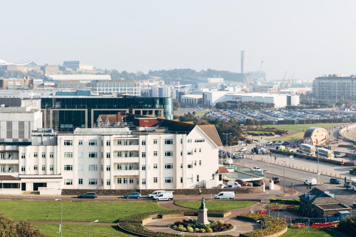
Retail and town centre in St Helier
This plan wants to define two distinct areas to encourage more activity in town to help the retail industry.
There would be a core retail area in St Helier.
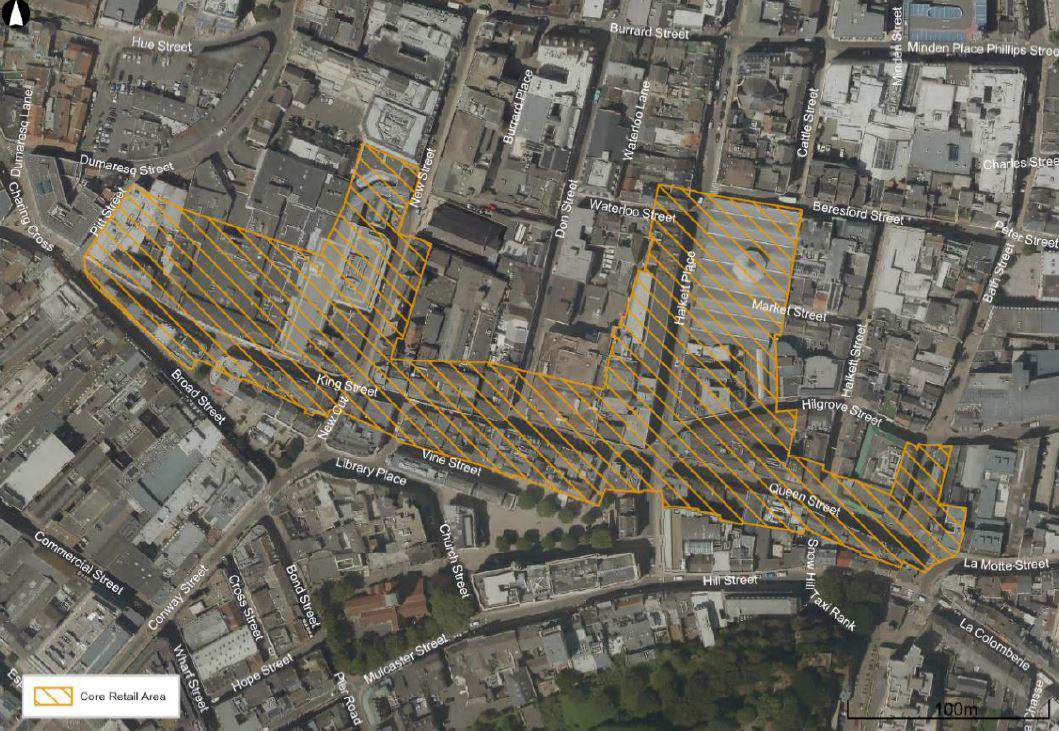
New large retail development in St Helier would be focused in this area. It could only go outside the area if it could prove that it would adversely impact the function of the core retail area.
"The retail provision at Les Quennevais precinct and Red Houses serves as the island’s secondary shopping centre. To help support and renew the retail offer and vitality of this area, the Island Plan seeks to manage and protect existing retailing and complementary town centre activity here.
"Proposals for a change of use away from retailing or town centre uses within the defined centre at Les Quennevais will need to demonstrate that there is no market demand for the continued use of the premises for retail or town centre use (on terms that reflect the lawful use and condition of the premises) for a period of time appropriate to the market for the use of the building; and justify how an alternative use is compatible with and can contribute to the vitality of the area.
"The plan will also enable and encourage the development of new retail and complementary town centre activities, such as leisure and entertainment, arts and culture, and daytime and evening economy uses, within the defined centre of Les Quennevais."
Large retail developments would not normally be supported outside the St Helier town centre and defined centre at Les Quennevais 'because out-of-centre retail developments tend to be self-contained facilities that can draw shoppers away from the existing centres to the detriment of their vitality'.
Smaller retailers like shops, newsagents and pharmacies would only be supported if the existing provision is not up to standard.
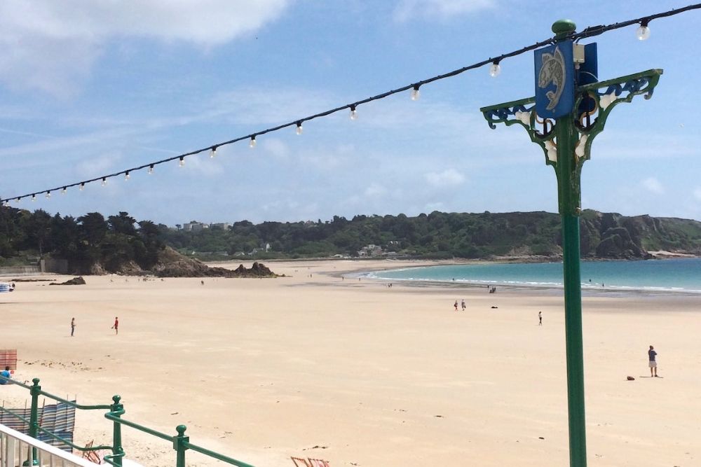
New bars, nightclubs, restaurants, cafes, takeaways, arts, and cultural venues would be supported in St Helier, the Les Quennevais defined centre and tourist destination areas such as St Aubin and St Brelade's Bay.
"Beach kiosks and mobile catering facilities can add to the enjoyment of a trip to the beach; a stroll along a promenade; or a walk along the cliff paths. It is important, however, that any such facilities are sensitively designed and sited and, where only acceptable as a mobile facility, are removed in accordance with specified times of operation. Proposals for new facilities will only be supported where they make use of existing buildings or structures.
Agent of change’ principles will be applied to new development in proximity to existing noise- and other nuisance-related daytime and evening economy uses – of particular relevance to theatres, music venues, restaurants, public houses, bars and nightclubs. Agent of change principles places the responsibility for mitigating the impact of noise and other nuisances firmly on the new development. This means that where new developments are proposed close to existing uses applicants will, for example, need to design them in a more sensitive way to protect the new occupiers, and/or to ensure suitable mitigation such as the soundproofing of the existing venue."
Office accommodation
The plan states that St Helier should be the primary location for new offices.
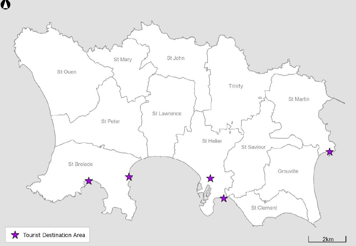
Visitor Accommodation
This plan sets out 'Tourist Destination Areas' - where developing tourist accommodation will be encouraged. They are in St Helier, At Aubin, Gorey, and St Brelade's Bay.
The government says there is limited opportunity for such development around the coast and in the countryside, but opportunities do exist.
"In considering proposals for the provision of new and the enhancement of existing visitor accommodation around the coast and in the countryside, any such proposals will only be supported where they do not harm landscape or seascape character. The highest level of protection will be given in the Coastal National Park. This not only includes consideration of their visual impact, but also the potential impact of any intensification of use, including the generation of traffic relative to the capacity and character of local roads, which may affect the sense of peace and quiet, and remoteness of a location.
"Such consideration would also apply to any proposals for the use of land designed to cater for touring units - including motor-caravans, motorhomes, touring vans and campervans – to serve the needs of visitors or islanders."
Protecting agricultural land
The government says this plan 'maintains a precautionary approach' to protecting this land.
"Proposals for the development of agricultural land must be accompanied by adequate information to justify the proposal; and which enables an assessment of the impact of the development upon the agricultural industry to be made. Where the supporting information is insufficient, proposals will not be supported."
More provision of local produce to support the local market will be encouraged.
"The development of a new or extended farm shop outside of the built-up area will be supported where it does not exceed 100sqm (gross internal floor area); is ancillary to an existing farm holding; and is based on the sale of fresh local produce, which includes produce from that farm.
"The type, range and origin of goods sold will be controlled by condition or planning obligation agreement. Future development will be controlled to prevent further changes of use.
"Proposals for diversification in the countryside must be accompanied by a business plan which justifies the location of the development in the countryside; and demonstrates its contribution to the rural economy."
New agriculture buildings in the countryside would need to justify why using existing or under-used buildings can't be used.
Re-development of glasshouses for non-agricultural uses would be discouraged. Livery stables and riding school developments would only be supported if there is proof they will make a genuine contribution to the rural economy.
Fishing and aquaculture
New facilities for fishing and aquaculture that are essential for the industry would be supported within St Helier.
"The aquaculture box in the Royal Bay of Grouville will be safeguarded from other forms of development which might harm the viability and integrity of this area for the purposes of aquaculture. The development of new, or the extension of existing, aquaculture infrastructure in the Royal Bay of Grouville aquaculture box will be supported.
"The development of new, or the extension of existing, aquaculture infrastructure in other parts of the inter- or sub-tidal zone will not be supported."
Community facilities
The Environment Minister says he will work with the Children and Education Minister to make sure high priority is given to developing new and improved school buildings.
New or extended health and social care facilities would be suppoted when they are in the built-up area, within the grounds of an existinf facility, ow within the new hospital development site.
Developments relating to the new hospital would be 'afforded the highest level of priority'.
"Proposals for associated infrastructure and relocation of existing services, where these are necessary to enable the delivery of the hospital but will be outside of the site approved by the States Assembly, may be considered as enabling and linked development and their delivery secured by planning obligation agreement, as appropriate and necessary."
New community facilities would also be encouraged within the built-up area or within the grounds of current community facilities.
Large sports centre developments would have to be within sites designated as sports and leisure areas at Les Quennevia School, Le Rocquier School, Springfield Stadium, the Jersey Rugby site, and Southwest St Helier Planning Framework Area.
"The redevelopment of the public swimming pool and/or cinema on the St Helier Waterfront will be supported where the prior provision of alternative facilities in Town can be assured, which may be secured through the use of planning obligation agreement, as required.
"The development of limited new sports, leisure and cultural facilities outside of the built-up area will only be supported where a coast or countryside location is necessary and justified, and where use is made of existing buildings, or, the provision of new or extended buildings will be limited, and the development will not give rise to an unacceptable intensification of use.
"The redevelopment of existing sports, leisure and cultural facilities for alternative uses will normally only be supported where it can be demonstrated that the use has become redundant and is otherwise surplus to wider community needs."
Open spaces
Sites have been safeguarded for future open space development, which includes:
- Proposed extension to the Millennium Town Park
- Development of Warwick Farm as a country park
- Access to Grands Vaux Reservoir and valley woodland
"To help provide a recreational amenity in the countryside it is proposed that the use of public land at Warwick Farm is released for development as a country park for the benefit of town residents. The site is located to the north of Town and there is potential to create and enhance access to it through the green lane and public footpath network in Vallée des Vaux, and to explore linkages to Fern Valley and Bellozane.
"The site is currently leased, but upon cessation of the current use, it is proposed that the site is brought forward to be re-purposed as a St Helier Country Park. Its development as country park would need to be resourced through the Government Plan process and guided by supplementary planning guidance."
Safe and welcoming spaces for play would be a requirement for new residential developments.
"It should also be a consideration in the design of the space around other buildings and public realm enhancements. The scale and nature of space for play required will be proportionate to the scale of development proposed and this will be assessed in light of the potential occupancy of the development.
"Play space may be provided as outdoor play equipment, playscapes (landscape design that incorporates play features), space for ball games and dedicated space that encourages safe bike riding, skateboarding and scootering. In some circumstances, indoor communal space may form part of the space for play contribution, such as communal games rooms or youth facilities. Other types of space for play will be considered where the developer has undertaken appropriate consultation and there is clear evidence of community support."
Access to the countryside
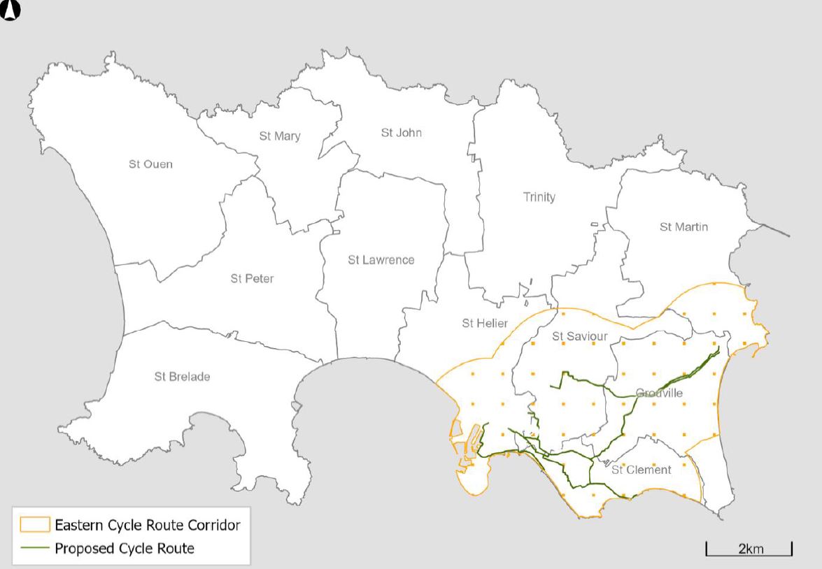
The plan sets out a long-term objective to create at least four north to south and two east to west routes linking from coast to coast.
"The north coast footpath, from White Rock near Rozel to Grosnez in St Ouen, provides a major strategic recreational east-west route. The Railway Walk links Corbière to Town, via St Aubin and Les Quennevais, with additional connectivity to St Peter’s Village. The St Lawrence Millennium Walk in Waterworks Valley; and the St Peter’s Valley pedestrian and cycle path make significant contributions to the development of strategic north-south routes, with ongoing work to identify opportunities elsewhere, which may be particularly supported by utilising and improving the network of Green Lanes.
"The development of new off-road routes and links that can deliver improved public access to the coast and the countryside across the island, and help meet the objectives of the Countryside Access Strategy will be supported, having regard to mitigating their impact upon the character of the coast, countryside, and biodiversity.
"Specifically, Grands Vaux Reservoir and valley, spanning the parishes of St Helier, St Saviour and Trinity, presents a significant opportunity to create access to the countryside from Town, and to provide a link into the northern parishes, whilst also providing new recreational amenity space.
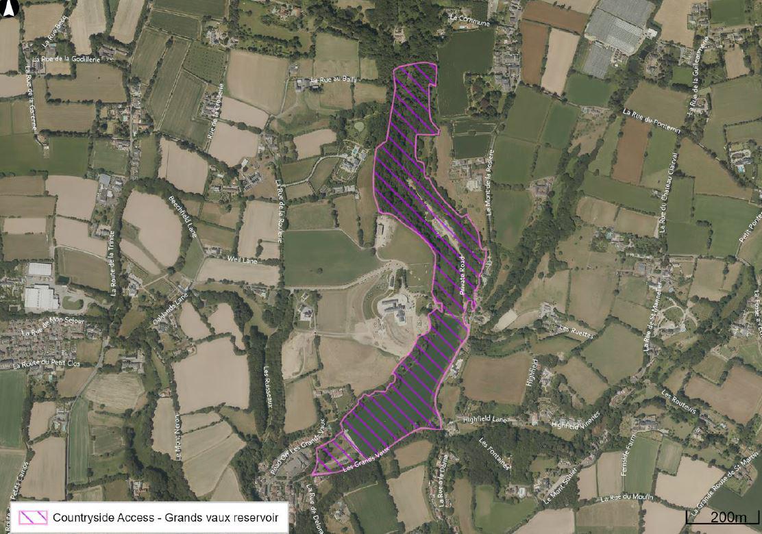
"The potential to secure public access around the reservoir and along the valley is dependent upon the ability of Jersey Water to consolidate and relocate some of its operations from its Grands Vaux site. The potential public benefit to be realised through any such relocation can form part of the consideration of any linked development proposals."
Allotments would be supported where it is in or near a built-up area, can be reached directly by public transport, does not seriously impact the landscape, and does not result in the permanent loss of high-value agricultural land.
Travel and transport
Travel plans would be needed for larger developments to show it will promote and encourage more sustainable travel.
"Proposals should demonstrate how safe and suitable access to the site can be achieved for all users, and all modes, including securing adequate visibility at connections to the road network; and considering any significant impacts from the development on the transport network, individually or cumulatively, in terms of capacity, congestion and highway safety. There will also be a need to demonstrate how the development helps to create places that are safe, secure and attractive, and which minimise the scope for conflicts between pedestrians, cyclists and vehicles, whilst allowing for the efficient delivery of goods, and access by service and emergency vehicles."
The plan states that 'secure and conveniently located cycle parking facilities' should be available in all new developments that have the potential to attract cyclists.
"Where appropriate, developments will also need to make provision for changing rooms, showers, drying facilities and lockers, together with electric charging infrastructure. Standards for the provision of cycle parking and associated infrastructure will be set out in supplementary planning guidance, to be issued by the Minister for the Environment.
"In developments where the required cycle parking facilities cannot be accommodated (e.g. in certain compact town centre sites), financial contributions will be expected towards public provision of alternative facilities elsewhere. Commuted payments from various developments may be pooled to provide public cycle parking within a locality."
New developments will be assessed to see how they could contribute towards further developing the eastern cycle route network and to make sure it does not prejudice more elements of the network.
Reprioritising road space
Bridging the Ring Road: "The Ring Road represents a significant boundary around the perimeter of the town. The proposal seeks to mitigate the severance caused and change its function to not only benefit vehicles but also people."
Active Travel Network: "This concept seeks to establish a number of key routes that prioritise movement by walking and cycling as part of an active travel network."
Growing a vibrant core: "In this area, a new relationship will be established between people, place and vehicular traffic that improves the environmental, cultural, economic and social wellbeing of the core and its communities."
Creating liveable neighbourhoods: "Liveable neighbourhoods harness the opportunity to place people back at the heart of their streets and the public realm, to deliver a people-focused approach to their design. With a growing desire to return the ownership of neighbourhood streets back to the residents; walkability and cyclability will be used as a catalyst for developing sustainable, healthy, and attractive streets."
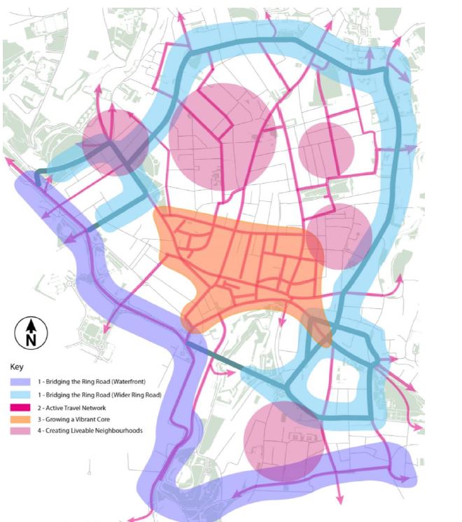
"This Island Plan will support interventions that help reduce the dominance of cars in St Helier, which could include reduced carriageway widths and speeds, at-grade footways and crossing points, footway buildouts and greening, depending on the identified scope for change. Achieving such a reduction can enable increased active travel by significantly improving the sense of place, feeling of enjoyment of space, and improving perceived and actual safety."
The development of five or more homes, office of retail floorspace of over 200sqm, or other development that could bring a significant number of people in and out of a site would be supported where it is within 400m of a bus route.
"Further investment and development of the island’s bus service can help to further the objectives of the STP (Sustainable Transport Policy). The Island Plan will support this by seeking to ensure that major new development is close to (within 400m or under five minutes’ walk of a bus route) and served by a regular bus service, where it is safe and accessible to use."
Creating off-street car parking spaces in town would not be supported unless it's for a 'meanwhile use' such as short-stay shopper parking.
 CI teams win gold and bronze at inter-island women’s football tournament
 Jersey's armed forces celebrated
 Remembering Clinton Pringle ten years on
 Lyndon's list of picks for Ministerial jobs revealed
 Man found guilty of violently attacking his date
 Inter-island women's football tournament kicks off in Guernsey
 Hottest Jersey day on record
 Highs of 39°C forecast on 5th day of Jersey's June heatwave


Comments
Add a comment